
How Do Satellites Take Pictures of Earth? The Amazing Truth Revealed in 2026
Introduction
Have you ever looked at a satellite photo on your phone and wondered how it got there? It feels almost magical. A tiny machine floating hundreds of kilometers above us somehow captures a sharp photo of your street, your city, or even your backyard. So how do satellites take pictures of Earth? The short answer is that satellites use powerful cameras and sensors that detect light and radio waves, then send that data back to ground stations on Earth. But there is a lot more happening behind the scenes, and it is genuinely fascinating once you understand it.
In this article, we will break down exactly how satellites take pictures of Earth, step by step. We will look at the cameras and sensors involved, explain the difference between optical and radar imaging, and answer common questions like whether satellites can see through clouds or take pictures in real time. By the end, you will have a complete picture of how this incredible technology works.
How Do Satellites Take Pictures of Earth? A Simple Breakdown
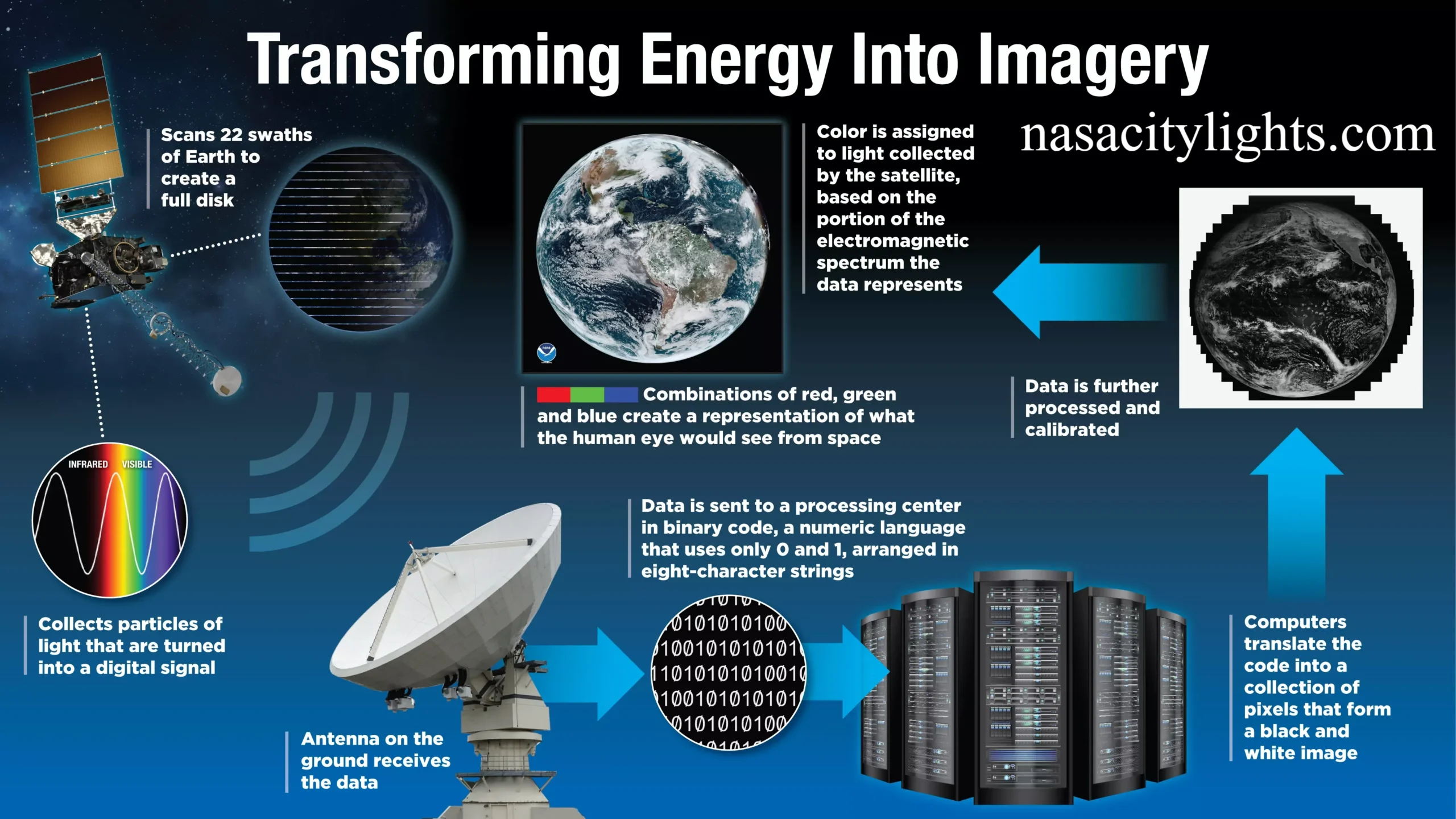
At its core, satellite photography is not that different from how your smartphone camera works. The main difference is scale and distance. Satellites orbit anywhere from a few hundred kilometers to over 35000 kilometers above Earth. From there, they use specialized sensors to collect light or radio signals reflected from the planet’s surface.
Here is the general process:
- The satellite orbits Earth following a fixed path.
- Its sensor detects light, heat, or radio waves bouncing off the ground.
- This data is converted into digital signals.
- The satellite transmits the signals to a ground station using radio waves.
- Software on Earth processes the raw data into a viewable image.
This entire cycle can happen within minutes, though sometimes it takes longer depending on the satellite’s orbit and the ground station’s availability.
What Cameras Do Earth Observation Satellites Use?
Satellites do not use ordinary cameras like the one on your phone. They carry highly advanced instruments called sensors, which are built to capture much more detail than a regular lens ever could.
Most Earth observation satellites use one of these sensor types:
- Optical sensors that capture visible light, similar to a digital camera but far more sensitive.
- Multispectral sensors that record different wavelengths of light, including infrared, to reveal things invisible to the human eye.
- Radar sensors that send out radio waves and measure how they bounce back.
- Thermal sensors that detect heat signatures on the ground.
These instruments often work together on the same satellite, giving scientists a much richer view of Earth than a single camera ever could.
How Do Satellites Capture Images From Space?
Once the sensor is ready, the actual image capture works a bit differently than you might expect. Satellites do not simply snap a photo like a tourist with a camera. Instead, many satellites use a technique called pushbroom scanning.
In pushbroom scanning, a narrow strip of sensors captures a thin line of the ground below. As the satellite moves along its orbit, it continuously scans new strips of land, and these strips are stitched together to form a complete image. This method allows satellites to cover huge areas of Earth without needing to stop and point at each spot individually.
Some satellites also use whiskbroom scanning, where a single sensor sweeps back and forth across the ground. Both methods rely on the satellite’s constant motion to build a full picture over time.
Can Satellites Take Real Time Pictures of Earth?
This is one of the most common questions people ask, and the answer is a bit nuanced. Most satellites cannot stream a live video feed of your exact location the way a security camera can. Instead, they capture images during specific passes over an area and send that data down later.
However, some newer satellites are getting close to real time capability. Weather satellites, for example, can update images every few minutes because they sit in a fixed position relative to Earth. Still, for detailed high resolution imagery of a specific location, there is usually a delay ranging from a few hours to a few days.
How Often Do Satellites Photograph the Same Location?
This depends heavily on the satellite’s orbit and purpose. Satellites in low Earth orbit move quickly and cover the entire planet, but they only pass over the same spot once every one to sixteen days, depending on the mission.
Geostationary satellites are different. They stay fixed above one point on Earth, which is why weather satellites can capture the same region continuously. This constant view is perfect for tracking storms and weather patterns in near real time.
Companies that operate large satellite constellations, like those with dozens of small satellites working together, can revisit the same location multiple times per day. This is incredibly useful for tracking changes quickly, such as monitoring wildfires or crop growth.
Optical vs Radar Satellites Explained
Understanding how do satellites take pictures of Earth also means understanding the two main imaging approaches used today.
Optical satellites work like giant digital cameras. They rely on sunlight reflecting off Earth’s surface, which means they only work well during daylight and clear weather.
Radar satellites work completely differently. They send out their own radio waves and measure the signal that bounces back. Because they generate their own energy source, radar satellites can capture images day or night, and even through clouds and rain.
Here is a quick comparison:
- Optical satellites produce highly detailed, natural looking images.
- Radar satellites work in any weather condition and at any time of day.
- Optical satellites struggle with cloud cover.
- Radar satellites are excellent for monitoring floods, ships, and land changes hidden by clouds.
Both types have their strengths, and many organizations use a combination of the two for the most complete picture.
How Clear Are Satellite Images?
Image clarity depends on something called spatial resolution, which refers to the size of the smallest object a satellite can detect. This is measured in meters per pixel.
For example, a satellite with one meter resolution can distinguish objects as small as a car. Some advanced commercial satellites can achieve resolutions below thirty centimeters, sharp enough to make out small details on rooftops or vehicles.
Government and military satellites often have even higher resolution capabilities, though exact specifications are usually classified. For everyday use, most publicly available satellite imagery ranges between thirty centimeters and ten meters, which is more than enough for mapping, agriculture, and urban planning.
Do Satellites Take Pictures Through Clouds?
Optical satellites cannot see through clouds because they rely on visible light. If clouds cover an area, the resulting image will simply show white cloud cover instead of the ground.
This is where radar satellites shine. Since radar sensors use radio waves instead of light, they can penetrate clouds, rain, and even darkness. This makes radar imaging essential for disaster monitoring, since storms and floods often bring heavy cloud cover exactly when clear images are needed most.
Which Satellites Provide Earth Imagery?
There are two broad categories of satellites that provide Earth imagery today.
Government satellites are operated by space agencies and are often used for scientific research, weather forecasting, and national security. These programs have provided decades of continuous Earth observation data.
Commercial satellites are operated by private companies and often provide higher resolution imagery to businesses, governments, and even the public. Many mapping apps and agricultural tools rely on data purchased from these commercial providers.
Together, these satellites create a massive global network constantly capturing images of our planet.
How Are Satellite Images Used?
The applications for satellite imagery go far beyond simple maps. Here are some of the most impactful uses:
- Weather forecasting and storm tracking
- Disaster response, such as identifying flood zones or wildfire damage
- Agriculture, including monitoring crop health and irrigation needs
- Urban planning and infrastructure development
- Climate research and tracking deforestation
- National security and defense monitoring
- Navigation apps and mapping services you use daily
I find it amazing that the same technology helping farmers monitor their fields is also helping scientists track climate change on a global scale.
AI and the Future of Earth Imaging
Artificial intelligence is transforming how satellite images are processed. Instead of humans manually reviewing thousands of photos, machine learning models can now automatically detect changes, identify objects, and flag anomalies within seconds.
Looking ahead, we can expect smaller and cheaper satellites, faster revisit times, and even sharper resolution. Some companies are already testing satellites capable of capturing near real time video rather than static images. The future of Earth imaging is moving fast, and it is only going to get more impressive.

Final Thoughts
So, how do satellites take pictures of Earth? It comes down to a combination of advanced sensors, constant orbital motion, and powerful ground based processing that turns raw data into the stunning images we see today. Whether it is an optical camera capturing natural light or a radar sensor cutting through clouds, satellites give us a view of our planet that was unimaginable just a few decades ago.
Next time you check the weather or explore a map online, remember the incredible technology working behind the scenes. What part of satellite imaging surprised you the most? Feel free to share this article with someone who loves space and technology as much as you do.
Frequently Asked Questions
How do satellites take pictures of Earth without a normal camera? They use specialized sensors that detect light, heat, or radio waves instead of a standard camera lens, allowing them to capture far more detail than typical photography.
Can satellites see individual people? Most publicly available satellites cannot identify individual people clearly. Their resolution is generally designed to detect objects like cars or buildings, not fine human features.
Do all satellites take color photos? No. Some satellites capture black and white or infrared images, while others combine multiple wavelengths to create color composite images.
How long does it take for a satellite image to reach Earth? It varies, but many images are transmitted and processed within a few hours, though some can take a day or more depending on the satellite and ground station availability.
Are satellite images free to access? Some government satellite programs offer free public imagery, while high resolution commercial images usually require payment or subscription.
Why do some satellite images look blurry? Blurriness can result from lower resolution sensors, atmospheric interference, or cloud cover affecting the optical sensor’s view.
Can satellites take pictures at night? Optical satellites struggle at night since they rely on sunlight, but radar and thermal sensors can capture useful images regardless of lighting conditions.
nasacitylights.com
Email: johanharwen314@gmail.com
Author Name: Hamid Ali
About the Author: Hamid Ali is a technology writer who enjoys breaking down complex science and space topics into simple, easy to understand articles. He is passionate about exploring how modern technology, from satellites to artificial intelligence, shapes the way we see and understand our world.