
NASA Earth Observation Satellites Explained: The Sky Watchers Guarding Our Planet in 2026
Introduction
Have you ever wondered how scientists know a hurricane is forming days before it hits land? Or how they track a glacier melting thousands of miles away? The answer lies above your head, quietly orbiting Earth right now. In this article, you will get NASA earth observation satellites explained in a way that actually makes sense, without the technical jargon that usually clutters this topic.
These satellites are some of humanity’s most powerful tools for understanding our changing planet. They watch oceans rise, forests shrink, storms grow, and ice sheets crack, all in real time. By the end of this guide, you will know exactly what these satellites do, how they work, and why they matter to your daily life, even if you have never looked up at the sky and thought about it.
Let us break it all down step by step.
What Are NASA Earth Observation Satellites?
NASA Earth observation satellites are spacecraft that circle our planet and collect data about its land, oceans, atmosphere, ice, and living systems. Think of them as security cameras for Earth, except they never blink and they see things human eyes cannot.
These satellites carry specialized instruments that measure temperature, moisture, gas levels, vegetation health, and much more. NASA has been building and launching these tools for decades, and today they form one of the most detailed monitoring networks ever created.
When people search for nasa earth observation satellites explained, they usually want to understand the basics first. So here it is in plain terms: these satellites are Earth’s eyes in space, and they never stop watching.
How Do Earth Observation Satellites Work?
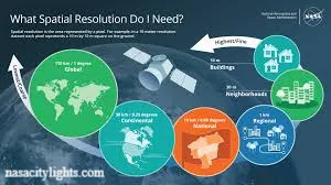
Earth observation satellites orbit the planet at different altitudes and angles depending on their mission. Some circle from pole to pole, capturing the entire globe every few days. Others stay fixed above one spot, watching a single region continuously.
Each satellite is equipped with sensors that detect different types of energy.
- Optical sensors capture visible light, similar to a regular camera, but far more advanced.
- Infrared imaging detects heat, which helps track wildfires, volcanic activity, and ocean temperatures.
- Radar sends signals to the ground and measures how long they take to bounce back, useful for mapping terrain even through clouds.
- Lidar uses laser pulses to measure elevation with incredible precision, often used for ice sheet thickness.
- Microwave instruments can see through clouds and darkness, making them ideal for tracking storms and soil moisture.
Once collected, this data gets transmitted to ground stations, processed by scientists, and turned into maps, models, and forecasts that we all rely on.
What Do NASA Satellites Monitor?
NASA satellites keep an eye on nearly every system that keeps our planet functioning. Here is a quick breakdown of what they track.
- Global temperatures and climate patterns
- Sea level rise and ocean currents
- Glacier and ice sheet changes
- Forest cover and deforestation
- Wildfire spread and smoke plumes
- Hurricane formation and strength
- Drought conditions and water scarcity
- Flood zones and river levels
- Air quality and pollution levels
- Crop health and agricultural output
This constant monitoring gives scientists a clear, ongoing picture of how Earth is changing, season by season and year by year.
Why Are Earth Observation Satellites Important?
Without these satellites, we would be flying blind when it comes to major environmental events. They give us early warnings for disasters, helping save lives and property. They also provide long term data that shows patterns humans could never detect from the ground alone.
I find it fascinating that a single satellite image can reveal decades of environmental change in one glance. That kind of perspective is impossible to get any other way. This is exactly why understanding nasa earth observation satellites explained matters, not just for scientists but for anyone who cares about the planet’s future.
Which NASA Satellites Observe Earth?
NASA operates a fleet of missions, each designed for a specific purpose. Here are some of the most important ones.
Landsat
The Landsat program has been capturing images of Earth’s surface since 1972, making it the longest running satellite record we have. It tracks land use changes, urban growth, and natural resources.
Terra and Aqua
Terra focuses on land, atmosphere, and ice, while Aqua specializes in water cycles, including rainfall, evaporation, and ocean temperature.
Aura
Aura studies the atmosphere, particularly ozone levels and air pollution, helping researchers understand how gases move around the globe.
ICESat 2
This satellite uses laser technology to measure the height of ice sheets, glaciers, and sea ice, giving precise data on polar melting.
SWOT
Short for Surface Water and Ocean Topography, SWOT measures water levels in lakes, rivers, and oceans with remarkable accuracy.
Sentinel 6 Michael Freilich
A joint mission with European partners, this satellite tracks global sea level rise with extreme precision, continuing a data record that spans decades.
Together, these missions form the backbone of what people mean when they search for nasa earth observation satellites explained.
How Do Satellites Track Climate Change?
Satellites track climate change by collecting consistent data over long periods. A single measurement means little, but decades of measurements reveal trends. For example, satellites have documented rising global temperatures, shrinking ice caps, and increasing ocean heat content.
They also measure greenhouse gas concentrations in the atmosphere, giving researchers hard evidence of how emissions are affecting our planet. This long term consistency is what makes satellite data so valuable for climate science.
How Do NASA Satellites Monitor Weather and Natural Disasters?
When a hurricane forms, satellites track its path, wind speed, and intensity in near real time. This information feeds directly into forecasting models used by agencies around the world.
During wildfires, satellites detect heat signatures and smoke direction, helping emergency teams decide where to focus resources. For floods, satellites map water levels across huge areas that would take weeks to survey on foot.
This rapid, wide scale monitoring is one of the most practical benefits of NASA earth observation satellites explained through real world use cases.
What Data Do Earth Observation Satellites Collect?
Earth observation satellites collect a huge range of data types, including surface temperature, vegetation density, cloud cover, precipitation levels, and gas concentrations. They also gather elevation data, ocean salinity, and ice thickness.
All this information gets compiled into datasets that researchers, farmers, city planners, and governments use every single day.
How Are Satellite Images Used by Scientists?
Scientists use satellite images to build models, verify predictions, and study long term environmental patterns. A single image might show forest loss, while a series of images over ten years can reveal an entire deforestation trend.
Researchers also combine satellite data with ground based measurements to double check accuracy. This blend of space based and ground based science creates a fuller picture of what is really happening on our planet.
What Is NASA’s Earth Observing System?
NASA’s Earth Observing System, often called EOS, is a coordinated group of satellites and instruments designed to study Earth as one connected system. Rather than looking at land, ocean, and atmosphere separately, EOS studies how they all interact.
This system has been running for decades and continues expanding with new missions. It represents one of the most ambitious environmental monitoring efforts ever attempted, and it plays a central role whenever people look for nasa earth observation satellites explained in depth.
Real World Applications Beyond Science
Satellite data does not just stay in research papers. It shapes real decisions every day.
- Agriculture: Farmers use satellite data to monitor crop health and plan irrigation schedules.
- Disaster response: Emergency teams use real time imagery to guide rescue efforts.
- Weather forecasting: Meteorologists rely on satellite data for accurate short and long term forecasts.
- Water resource management: Officials track reservoir levels and drought conditions to manage supply.
- Environmental protection: Governments use satellite evidence to enforce conservation policies.
Global Collaboration
NASA does not work alone. It partners with NOAA for weather forecasting, USGS for land data, and ESA for joint missions like Sentinel 6. These partnerships combine resources and expertise, creating a more complete global monitoring network than any single agency could build alone.
Recent and Future Missions
NASA continues launching new missions to fill data gaps and improve accuracy. Recent projects focus on tracking carbon emissions, ocean health, and extreme weather with even greater precision. Future missions aim to improve resolution, expand coverage, and speed up data delivery so responders can act faster during disasters.
Final Thoughts
NASA earth observation satellites explained in simple terms come down to this: they are humanity’s way of keeping watch over our own planet. From tracking hurricanes to measuring melting ice, these satellites give us knowledge we could never gather any other way.
The next time you check a weather forecast or read about rising sea levels, remember that a satellite orbiting hundreds of miles above you helped make that information possible. What part of this technology surprised you the most? Feel free to share this article with someone who loves space or science as much as you do.
FAQs
What are NASA Earth observation satellites used for?
They monitor climate, weather, natural disasters, oceans, ice, and land changes across the globe.
How many Earth observation satellites does NASA operate?
NASA operates dozens of satellites, working alongside international partners for even broader coverage.
Can satellites predict natural disasters?
Yes, satellites help detect early warning signs for hurricanes, floods, and wildfires before they escalate.
What is the oldest NASA Earth observation program?
Landsat is the oldest, continuously operating since 1972.
Do satellites measure air pollution?
Yes, satellites like Aura track pollution levels and atmospheric gases worldwide.
How accurate is satellite climate data?
Extremely accurate, especially when combined with decades of consistent measurements.
Is satellite data available to the public?
Yes, much of NASA’s satellite data is publicly accessible for research and education.
nasacitylights.com
Email: johanharwen314@gmail.com
Author Name: Hamid Ali
About the Author: Hamid Ali is a science writer who enjoys breaking down complex space and environmental topics into simple, relatable content. He is passionate about helping everyday readers understand how technology shapes our understanding of the planet.